Bridging the Severn on foot
Bridging the Severn on foot
Written by Dr Rhoda Ballinger, SEP Chair
This month I walk across the Estuary across the Severn Bridge to discover hidden worlds along the estuary’s shores, amazing engineering innovations and more.
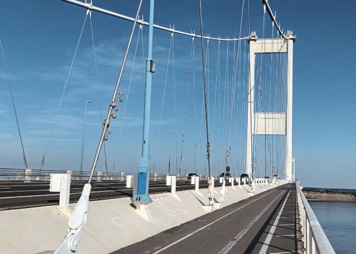
Heading towards the second tower on the Severn Bridge
An intense heatwave saw my original plans for a walk along the estuary between Sharpness and Aust with Environment Agency staff suddenly shelved. On a hot calm day – well, of course, the Severn Bridge (Pont Hafren) was the obvious place to be. So, with little preparation I set off to experience the estuary from yet another, bird’s eye perspective. This time I was accompanied by my husband, Geoff, who had grown up in Alveston, and who I thought might be able to provide some local detail, albeit he’d moved to Kent at the age of 10. Not entirely sure how long the walk would take or indeed exactly where to park to access the path across, we ventured out in the late afternoon sweltering heat which now, a few weeks’ later, it’s rather difficult to imagine!
The walk
Some Googling enroute led us to an uninspiring industrial estate on the edge of Chepstow where several bloggers suggested there was access by foot to the bridge. After a little exploration we eventually found signage associated with the Severn Bridge 5k Parkrun – phew, I thought, only 5 km! Passing under the M4 and admiring the wacky graffiti of the underpass, we located the path which surprisingly led up us through a delightfully calm and relatively cool woodland towards the bridge.
The sound of the roaring traffic rudely broke our peace as we ventured through a somewhat intimidating steel gateway onto the dusty path across the bridge. This was, of course, the Wye Bridge (Pont Gwy), which, at 408 m long and with its two towers, is quite impressive in its own right, though hardly noticeable when driving over ‘the’ bridge. Immediately, we realised this was not going to be an entirely pleasant experience, though: the thunderous vibrations from passing lorries alongside the near constant roar of other traffic were not only deafening, but meant that you had to be really careful not to step out from the narrow footpath onto the cycle/motor bike lane. Only the eastern, seaward footpath was open today due to maintenance work, so it was busy with other walkers, cyclists and even motor bikes. Much to our surprise we realised that the bridge is part of the Land’s End to John O’Groats long-distance cycle route! Well, if I was somewhat hot and sweaty crossing the bridge, others must be steaming, given the size of some of the panniers on their bikes.

Geoff posing in front of the graffiti in the Severn underpass
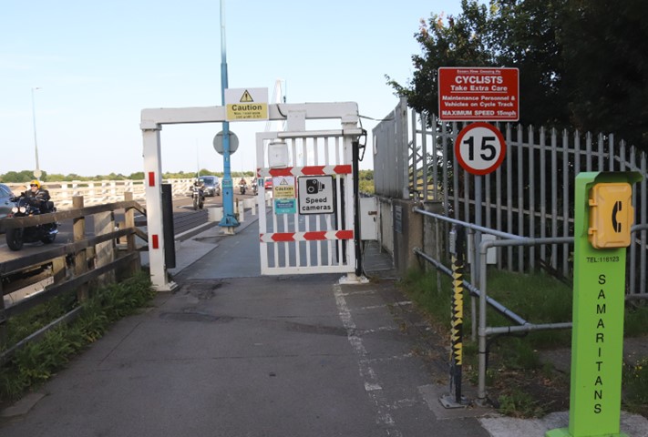
The slightly unwelcoming and intimidating entrance to the bridge walk!

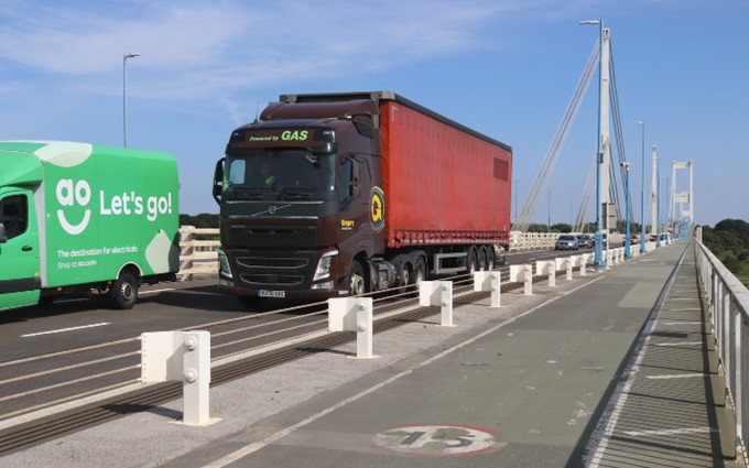
Thunderous traffic hurtling along the Wye Bridge (Pont Gwy)
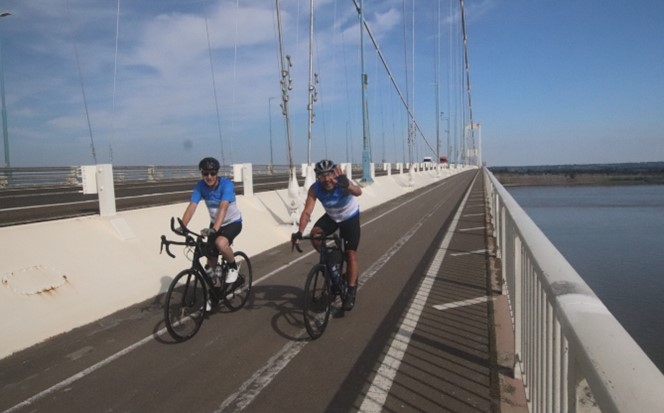
Two of the many friendly cyclists crossing the bridge
Vistas and troubled waters
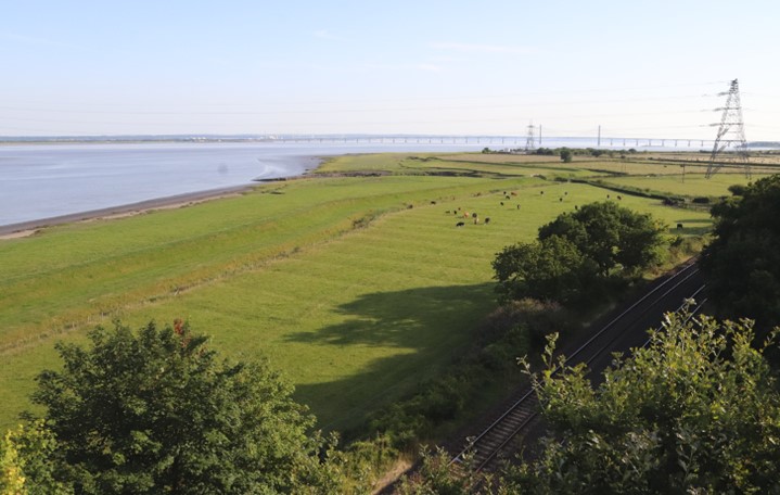
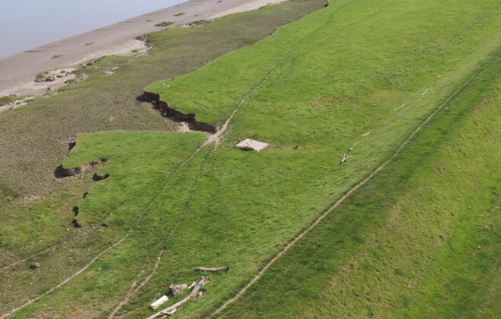
Eventually, I managed to block out the intruding noise to be able to admire the amazing vistas afforded by our elevated position along the bridge. Indeed, our bird’s eye views, alongside the ever-changing light and tides, made for a most memorable and, as the poet, Vikram Aarella, notes in their poem on the bridge, an ‘awesome’ experience. Not only were the hidden worlds of Beachley Barracks and the now infamous Tracey Island (St Twrogg’s Island, see my July blog) revealed, but the long shadows created by late afternoon sunshine enabled us to pick out all sorts of coastal features along and the near the shoreline –embankments forming vital coastal defences to miles of valuable agricultural land and the inter-city railway line, complex but beautiful vegetation patterns in the saltmarshes, as well as intricate tidal creeks, channels and gullies traversing the emerging intertidal mud flats for which our estuary is so renowned. Less well known are the ephemeral shapes of mythical beasts, crocodiles and other creatures which appear and disappear with the incoming and outgoing tides along the shore!
Once on the Severn Bridge proper, the distant panoramic views down the estuary were even more breathtaking, despite the slight haze. The wide expanse of the estuary’s waters is so impressive from mid-bridge, and the Prince of Wales in the distance looks so incredibly small. Capturing such views on camera on an ever moving, vibrating platform, was far from easy, however. Thankfully though, due to some careful planning (watching for breaks in the ‘heavy’ traffic and locating more stable, locations on the bridge, notably near the towers) and the use of exceptionally fast camera speeds, I eventually captured some half-decent photos to share with you. Unfortunately, you’d have to get up exceptionally early to do better and even writing a blog for SEP e-news is not worthy of that…
One of many vistas from the bridge – this one even reveals the ancient, medieval field patterns in the coastal plain.
Embankments and multiple shorelines along the Welsh coast
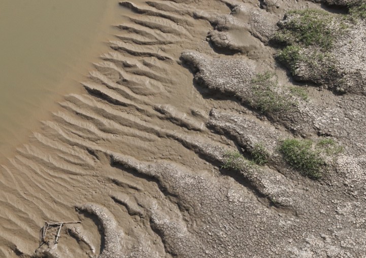
Mythical beasts along the muddy shores
As a trained physical geographer, the birds’ eye views of the swirling eddies in the tidal waters below us were amongst the most spectacular features of our walk. Richly coloured chocolate browns mix with grey blues and a multitude of other Severn Greys to create ever-changing eddies of all sizes and a visual art display like no other. Wow – I’d only been down there, traversing those waters a few weeks before on the Waverley. Even more crazy was the thought of the relatively small ferry crossing from Beachley to Aust which operated until the bridge opened in 1966. Given such potentially treacherous waters, no wonder Telford had considered building a bridge as far back as 1824! As we moved to the middle of the Severn Bridge itself, my thoughts turned to the amazing geology of the Aust cliffs and their similarity to the cliffs Heather and I had seen on my first e-news walk from Lavernock Point to Penarth. The alternating reds, browns, greens and greys of the Triassic rocks of the Aust SSSI are certainly a striking and welcoming feature as you approach the English coast and the 1960s old ‘Severn Service Station’ from which I caught my first-ever, memorable glimpse of the Estuary.
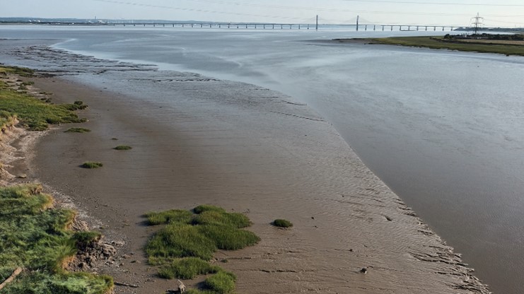
Distant views from the Prince of Wales bridge across the emerging mudflats
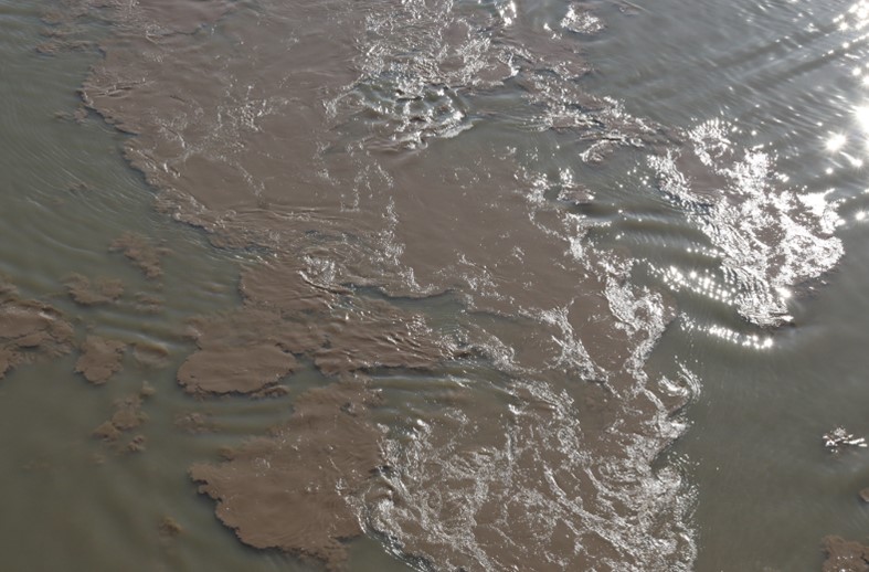
The chocolate turbid waters swirling below the bridge
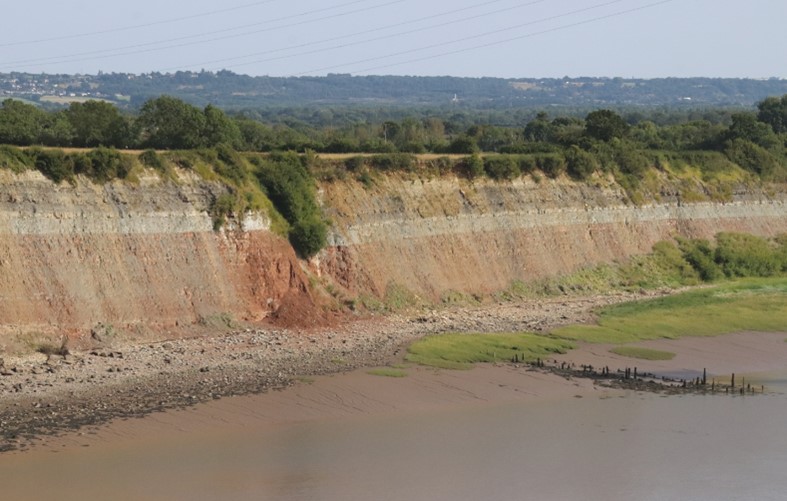
The dramatic Triassic cliffs at Aust
Having reached ‘the other side’ and aware of the dimming light and our much-reduced water supplies, we swiftly took our proof of passage photos (unfortunately, of dubious quality so not reproduced here!) before retracing our steps over the bridge, hopefully to take considerably less than the two hours it had taken to traverse the estuary on our outward walk. Despite our best efforts not to stop on our return, there was the inevitable photo opportunity to wonder at the newly emerged shorelines and even wider expanses of mudflat which had appeared since our outward walk, and also to study the ‘dog bones,’ best explained in the next section on bridge innovations!

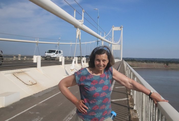
Self, unsuccessfully trying not to squint into the bright sunlight, near the centre of the bridge
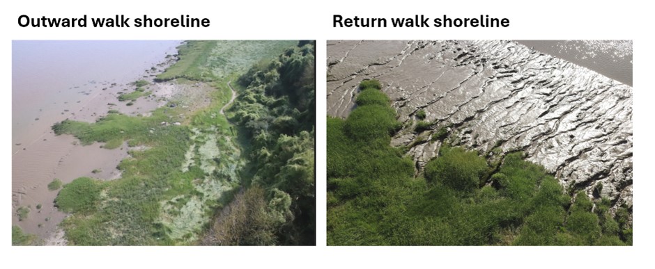
Differing shorelines on outward and return walks
The bridge – engineering innovations
Though constructed at a time of black and white television, and classic cars such as the Hillman Minx, Ford Cortina and Ford Escort, and completed in the year (1966) when the Monkees came to our TV screens and to some people’s walls (!), this is a bridge which leaves you impressed whether viewed from afar or on foot. The height of the towers, the lengths of the wire cabling and the gradient of the arching road/path, are all to be wondered at as you amble across the bridge – things you take for granted when travelling at speed by car. You also don’t really appreciate the huge efforts in engineering and construction which enabled such structures to be built and indeed to survive to this day, still supporting a major road artery nearly sixty years later. As we learnt from our scrutiny of the many plaques along the bridge, both the construction and refurbishment of the bridge, had come at some human cost, as lives had been lost during both phases.
I learnt later that this mighty bridge was many years in the design and development – perhaps a noteworthy point for other current proposed infrastructure projects in the Bristol Channel. Early engineering design proposals and associated wind behaviour studies in the 1940s and early 1950s, following local and national interest, were initiated and then abandoned by Government. However, these formed a useful context for later developments. This was never going to be a ‘plug and play’ bridge under the guidance of the eminent, chief engineer Gilbert Roberts. This notable individual had already completed pioneering work on high tensile structural steel and the use of welding instead of rivets for large steel structures (including ships) which had reduced the weight and subsequent costs of such structures. He had even been involved in the Forth Road Bridge which preceded the Severn by a few years. Dampening the Severn Bridge’s potential vibrations and oscillations, as well as keeping the weight of the bridge to a minimum in order to reduce costs, were key drivers in our bridge’s design. This resulted in several innovative features including the use of (cheaper) single cell box girders, a particular hanging of the wire-rope hangers and even shop fabrication of some sections, some of which were built by Fairfield-Maybey in Chepstow before being transported by river to the site. Such was the innovation involved in the Severn Bridge’s design that Roberts received multiple prestigious awards for his efforts, before being sought after to design bridges and other structures all around the world, including the famous bridge across the Bosphorus. However, there were some sceptics, including one eminent engineer who feared that the first fall of snow would see the Severn Bridge collapse! Fortunately, that never happened although there has been more than one occasion when the bridge has been closed due to high winds. The increasing volume of traffic crossing the bridge, however, was never envisaged during the 1960s. By the 1970s the bridge was reduced to single lane traffic prior to strengthening and restructuring in the late 1980s. Eventually, even this wasn’t enough to cope with the burgeoning demand, leading to the construction of the Second Severn Crossing (the Prince of Wales Bridge) in 1992.
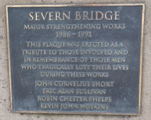
One of the plaques along the bridge, commemorating one of the bridge’s lesser-known tragedies
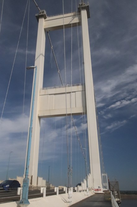
One of the mighty towers supporting the Severn Bridge
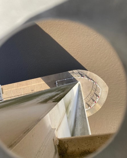
An impressive, if slightly scary view down to a bridge support (photo by Geoff Ballinger)
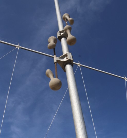
A dogbone, Stockbridge damper on a road support cable
Ode to the Severn Bridge
Two lands at last connected
Across the waters wide
And all the tolls collected
On the English side.
(Harri Webb)
Later engineering additions to the Severn Bridge were the somewhat mysterious dogbone structures attached to the road support cables, which we couldn’t help but notice as we plodded back towards Chepstow in the searing heat. These specialised Stockbridge dampers with their notable dumbbell shape help suppress wind-induced vibrations, reducing stress and fatigue in the cables. Designed by the Australian inventor and aviator, Philip Dulhunty, who also produced the world’s first battery-powered laptop computer, these dogbone dampers, apparently are a considerable improvement on the classic Stockbridge dampers devised in the 1920s. Minimising bridge oscillations has certainly attracted engineers’ attention ever since the dramatic collapse of the 1940 Tacoma Narrows Bridge (Galloping Gertie) into Puget Sound in Washington State. At least we weren’t subjected to any such wobbling, but then it was a very calm afternoon…
Key facts about the Severn Bridge (Pont Hafren)
- Bridge construction started: 1961
- Official opening of the bridge: 1966
- The World’s 43rd longest bridge span between towers!
- Designated as a Grade I structure in 1999
- Cost of initial building: £8 million
- Bridge constituent structures: Aust Viaduct, the Severn Bridge, the Beachley Viaduct, the Wye Bridge
The bridge – social engineering
As we approached the gates at the end of the Wye bridge and returned to the relative calm of the woodland we were able to chat (at last) and began to reminisce about our childhood memories. I remember the excitement of viewing the bridge and estuary from the old Severn Services enroute to a holiday in Cornwall. I recalled admiring the grace of the technological wonder as we drove over the bridge, albeit our excitement was slightly marred by the anxiety of finding the correct change for the toll booths on the Welsh side. Do take a look at Natalie Pithers’ wonderfully entertaining and vivid description of her childhood memories of crossing the bridge which echo some of my recollections and feelings.
Geoff fondly remembered his mother’s palpable excitement on attending the official opening of the Severn Bridge by HM Queen Elizabeth II. He also recalled crossing the bridge by car for the very first time – “a very small family car replete with odorous dog, Spike, and my parents’ friends, Frank and June, and their boisterous children. I also remember that visits to my uncle and aunt, who lived near Hay-on-Wye had used to involve a long car journey via Gloucester with the small treat of seeing an illuminated match as we passed the England’s Glory factory. Suddenly dad could drive via a more direct route over the bridge, bypassing Gloucester altogether – although he did have to do a lot of fumbling in pockets to find the toll charge. My childhood memory of approaching Wales was the sight of Beachley Army barracks and a large structure which I was convinced was part of an obstacle course recruits had to climb. Our recent walk revealed it was actually the camp chapel! As a child we sometimes took visitors to see and walk on the new engineering wonder. I have no memory of the noise of lorries – maybe lorries were quieter then!” Suddenly, afternoon excursions to South Wales for picnics were a fun and fashionable thing to do too. The coach loads of South Walians descending on Bristol for a day out were a talking point for the local Bristolians, particularly given the new visitors’ somewhat unfamiliar accents. Such was the excitement and interest in this new structure, that poems were even written about it. The one reproduced (left) is probably the best-known, though it was rather contentious at the time. From what I remember, it reflected negative feelings towards the bridge tolls and associated comments about ‘paying to enter Wales.’
We reflected on how the bridge must have changed the social and economic geography of the region more widely. As the US politician, Elijah Cummings has suggested bridges ‘determine the connnections … that people will encounter in their daily lives’ – we saw this in the local, foot traffic on the bridge as we passed a few people on our return walk we’d seen previously who appeared to be carrying their shopping – quite a long walk to go to your local, I thought! Cycling was always a ‘thing’ and Geoff recalled the time two childhood friends set out to cycle from Alveston to Chepstow, and back. “They did it, on small bikes and probably no gears, but nobody’d quite anticipated that the ride home would be in a police car, as they got stuck on the other side”.
Queen Elizabeth II had remarked on the potential for the bridge to change the economic prosperity of South Wales in her speech at the official opening in 1966. Inspired by the new connectivity associated with the bridge, a new vision for regional development was put forward in the 1971 study prepared for the Department of the Environment and Welsh Office ‘Severnside: a feasibility study.’ Despite the increasing prosperity of Cardiff, sadly any hopes for significant increases in economic growth in South East Wales weren’t realised. However, now, many decades later, and also following the construction of the Prince of Wales Bridge and the abandoning of road tolls, the Western Gateway partnership is beginning to redefine the region and propose ambitious forward-looking plans for Severnside and beyond.
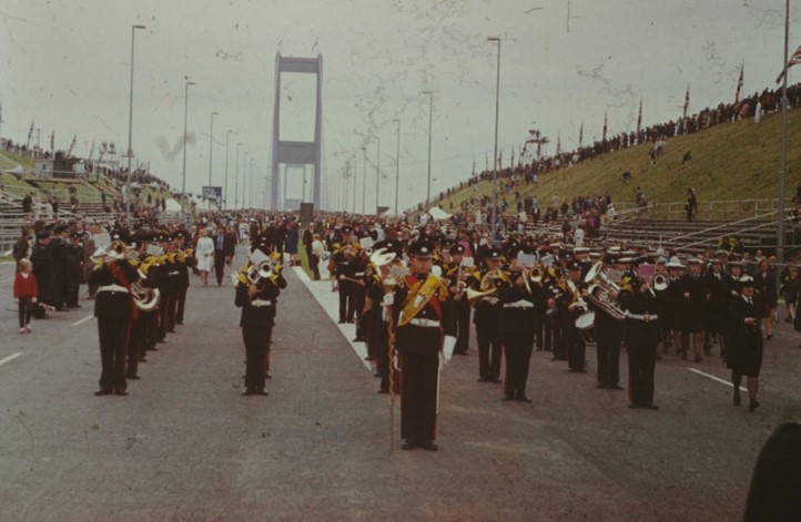
Massed bands at the official opening of the bridge by HM Queen Elizabeth II – one of many family photos of the occasion taken by the late Leslie Ballinger
Final thoughts
Reflecting on my short excursion across the mighty Severn Bridge/Pont Hafren, I’m reminded of the comment made by the US film-maker Bruce Jackson who suggested ‘‘Bridges become frames for looking at the world around us.’ Whilst I must have used the SEP logo with its stylised bridges on innumerable occasions, I hadn’t really thought too much about the bridge’s impact on the estuary and its people, until I’d completed this walk. Rambling across this mighty structure, I’d been granted a new perspective of the estuary itself – new vistas had emerged and hidden worlds had been revealed. The walk had also motivated me to research the bridge and its environs further, leading me to explore a number of current on-the-ground issues, which, as SEP Chair, I should be aware of. Of these, the future of the old Beachley Barracks site, following the MOD site closure in 2029, is now on my radar …
So, I’d encourage you to take a walk across the Severn and see what new perspectives and inspirations you gain from this fun, though somewhat noisy experience.
Further Reading
Gilbert Roberts. 18 February 1899 – January 1978, by OA Kerensky, Biographical memoirs of fellows of the Royal Society, Vol 25 (Nov 1979), 477 – 503, http://www.jstor.org/stable/769856,
A trip to the past – via Chepstow, by Natalie Pithers of Genealogy Stories
The Severn Bridge – History Points – https://historypoints.org/index.php?page=the-severn-bridge
The First Severn Bridge – by Phil Carradice – https://www.bbc.co.uk/blogs/waleshistory/2011/09/the_first_severn_bridge.html
Useful websites on walking the bridge
GPS Cycling and Walking Routes – Severn Bridge Walk Route – https://www.gps-routes.co.uk/routes/home.nsf/RoutesLinksWalks/severn-bridge-walking-route#google_vignette
Useful info on walking the bridge – https://www.tripadvisor.co.uk/ShowUserReviews-g190753-d12428909-r679581623-Severn_Bridge-Chepstow_Monmouthshire_South_Wales_Wales.html
Saturday Walkers Club – Severn Bridge Walk – https://www.walkingclub.org.uk/short-walk/severn-bridge/