Weather and Climate
The local weather around the Severn Estuary is influenced by the wider coastal environment it experiences. The ocean brings cool winds in summer and mild winds in winter, keeping the Estuary at a relatively mild temperature year-round. The number of days with sunshine can be variable, and often in winter and spring, many types of weather can occur within one day!
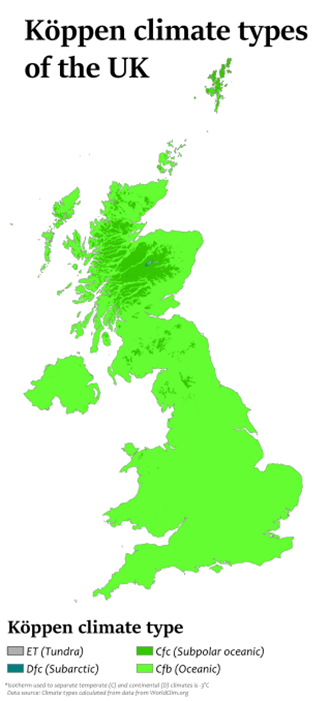
The climate within the Severn Estuary, along with much of the UK, is classified as an ‘Oceanic’ climate within the Köppen-Geiger Climate classification system. This system splits the entire planet into different climate zones, for example, tropical, arid, polar and continental. Characteristics of the Oceanic zone (Cfb) include cool winters and warm summers, with year-round rainfall.
Annual Temperature Range
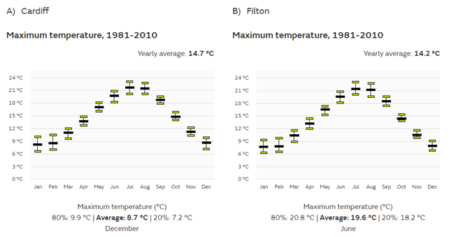
The annual temperature range of the Estuary is relatively mild, with warm summers and cool winters. At the Filton climate station (South Gloucestershire), the average maximum temperature is around 14.2°C, compared to 14.7°C at the Cardiff climate station. The minimum temperature for Filton and Cardiff is 7°C on average. Overall, Southwest England and South Wales have a maximum annual temperature of 13.4°C and an annual minimum temperature of 6.3°C. Maximum temperatures across the Severn Estuary region tend to peak around June to August, as shown in Figure 2.
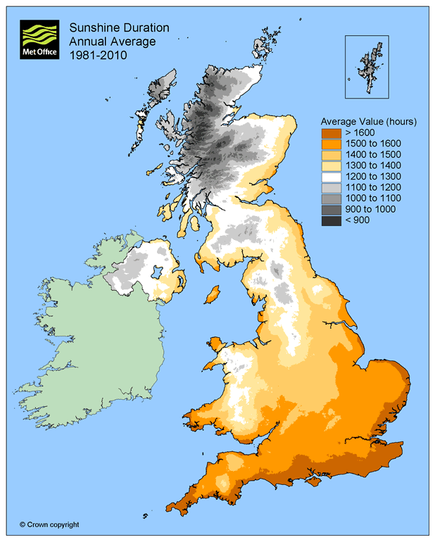
Annual Sunshine Hours
Britain’s west country is a relatively sunnier place than most of the UK, except for the South-east. Sunshine hours across South-west England and South Wales tend to peak from May to July, averaging a total of 1519 hours annually. Within Figure 3, the Severn Estuary is shown in the 1500-1600 hours band, making the Estuary a perfect place to explore under sunny skies!
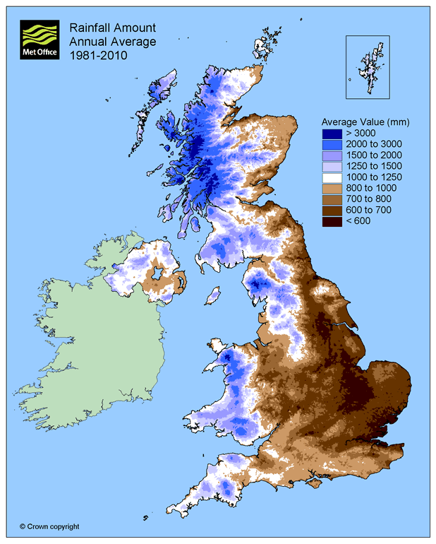
Annual Rainfall
The UK’s west coast experiences more rainfall than the east coast, because of the prevailing south westerly winds driving from across the Atlantic – the Severn Estuary is no exception, with South Wales and North Somerset being the rainiest places within the Estuary. Further eastwards, Bristol and Gloucestershire are drier. Figure 4 shows the east to west trend of increasing rainfall. The months of October to January see the most rainfall, whereas April to June are the driest months. Within the city of Cardiff, 1151 mm of rainfall falls annually, compared to 802 mm for Gloucestershire annually.
Influences on the Severn Climate
What produces the temperate, rainy, oceanic climate seen in the Estuary? The UK’s latitude (position on the globe from north to south) is actually equal to that of Canada! Therefore, the UK should really experience similar freezing temperatures and lots of snow as seen across Canada. However, the Jet Stream keeps the UK warm. The Jet Stream is a large, powerful column of wind blowing 5-7 miles above the earth’s surface. This air moves across the atmosphere, like a river, and brings with it differences in pressure and temperature. Depending on the position of the Jet Stream over the UK, which frequently changes, there will be either prevailing high-pressure systems or prevailing low-pressure systems. When the Jet Stream is positioned south of the UK, low pressure systems prevail, which bring with them wet and stormy weather – even in summer! The reverse occurs when the Jet Stream is to the north of the UK, bringing warm and calm weather. Check out the video below for more information!