Transport
The Severn Estuary area is bordered by an important transport network that links the two countries of England and Wales. This network has been influenced by the geography and topography of the region and it reflects both the historic and economic developments and requirements around the Estuary over the years. One of Wales’ main national road and rail network routes runs parallel to the south coast acting as a corridor, joining Wales with Ireland (linking to ferry routes), England and the rest of Europe. The network of roads, railways and ports was initially developed to serve the industrial needs of the South Wales Valleys in the 18th and 19th centuries. Today the road and rail transport networks around the Severn Estuary link the Welsh valleys to the city centres and port areas of Newport, Cardiff and Swansea, whilst in England they follow the main tourism, industry and conurbation districts of Weston-super-Mare, Avonmouth, Bristol and Gloucester.
Road
Significant volumes of road (and rail) traffic move throughout the Estuary area, both in and around Wales and Southwest England, including traffic originating in both countries, as well as elsewhere. Roads are the most extensive and comprehensive of transport networks in Wales and Southwest England, and hence are currently the most flexible mode of transport for freight. In fact, in 2020, 79% of freight moved within the UK was transported via roads. The M4 and M5 motorways are key parts of the road networks and are an important link for the Severn Estuary from South Wales and Southwest England to London, the Midlands and numerous international destinations.
Rail
There is an extensive rail network around the Severn Estuary, specifically centred around the urban areas of Cardiff and Bristol. In Wales, there was a 4.4% decrease in station use in 2019-2020 when compared to the previous year, aligning with a national decrease of 1.1%. It is likely that the impacts of the Covid-19 pandemic and flooding early in 2020 can be attributed to this fall. However, Cardiff Central, on the northern coast of the Severn Estuary, is the busiest station in Wales, with 25% of all station entries and exits nationwide. Journeys in 2020 in the South-West of England were very similar to the previous year at around 27 million. The electrification of the Great Western Railway, including new rolling stock and station improvements has been the largest rail infrastructure development in the region for almost a century. Started in 2010, it was to link London Paddington with Swansea, Bristol and Bath. The electrification works between London Paddington and Cardiff Central were completed in January 2020, with successful electrification of the Severn Tunnel after a challenging period of works for Network Rail.
Shipping and Ports
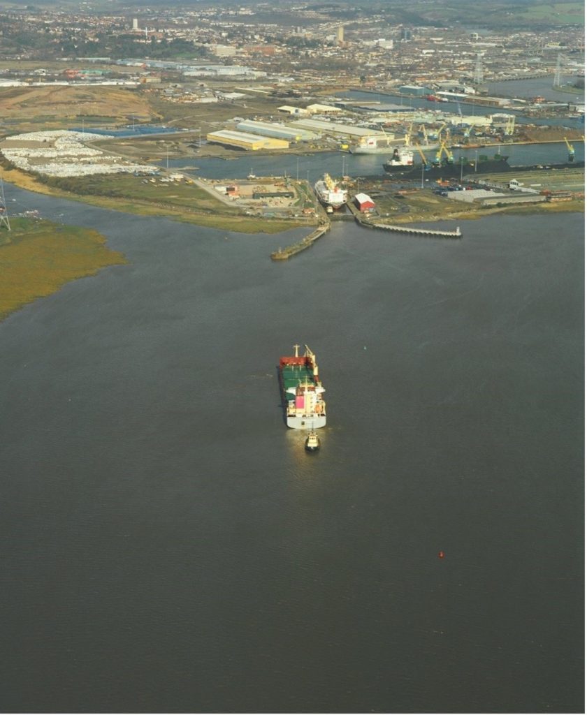
With 95% of international freight arriving in the UK by sea in 2020, ports around the country are incredibly important. The Severn Estuary ports are well-served by road and have generally adequate rail connections, although there is scope for development. Connections between modes of transport are important when planning the development of new port terminals. Cardiff, Newport, Bristol and Sharpness are the main ports within the Severn Estuary, responsible for handling a substantial proportion of UK trade, both domestic and foreign, whilst also acting as important players in the local and regional economy. In general, shipping in the UK is likely to expand as a low-carbon, economical method of both national and international trade. For more detailed information, take a look at the Ports & Shipping page below.
Bridges
The view of the Upper Severn Estuary is characterised by the two iconic Severn Bridges. The Severn Bridge and Second Severn Crossing are landmarks of the Estuary as well as major transport routes linking South Wales with Southwest England. The original Severn Bridge supports the M48 and joins Aust, South Gloucestershire on the English side of the Estuary to Chepstow at the mouth of the River Wye and Chapel Island. The bridge was opened in 1966 to replace the old ferry service crossing from Aust to Beachley.
In 1996 the Second Severn Crossing (see Fig. 1) was opened to relieve congestion on the local road network, and M5 motorway. New link motorways on the Avon and Gwent sides of the Estuary were constructed to divert the M4 motorway over the new crossing, whilst the existing route over the first bridge between Awkley in England and Rogiet in Wales was redesignated as the M48. The new bridge provides a direct link for the M4 motorway into Wales. In January 2018 both bridges were transferred to public ownership prompting a toll reduction as VAT was removed. Tolls have now been removed completely.
Pipeline
There are a number of pipelines straddling the Severn which transport oil and gas products. On the Welsh shores, a gas pipeline links Milford Haven to Gloucestershire before joining the wider UK pipeline networks in the Midlands. Across the water, at Avonmouth Docks, tankers discharge aviation fuel into the Bristol Aviation Fuel Terminal which feeds directly into the UK’s fuel pipeline and storage network.
Tunnel
The Severn Tunnel was built by the Great Western Railway (GWR) between 1873 and 1882. It is 4 miles 624 yd (approximately 7 km) long, although only 2¼ miles (3.62 km) of the tunnel is under the Severn Estuary itself. The Severn Tunnel links South Gloucestershire in England to Monmouthshire in South Wales and is part of the main (passenger and freight) railway line between London and South Wales.
Canal
The Severn Estuary is linked to two canals: the Monmouthshire & Brecon, and the Gloucester & Sharpness canals. The Monmouthshire & Brecon canal was used during the industrial revolution to transport coal from the mines in Brecon to the docks at Newport. Today the canal is landlocked, navigable and used only for recreational activities between Cwmbran and Brecon. On the English side of the Estuary, the 16 miles of the Gloucester & Sharpness waterway (once the broadest and deepest canal in the world) bypasses the meandering upper stretches of the Severn Estuary to link the commercial port of Sharpness with Gloucester’s historic docks (see Fig. 3). Despite its distance from the sea, the build specifications of the Gloucester & Sharpness canal enabled ocean going vessels to safely reach Gloucester; this allowed the county to compete with coastal docks, resulting in substantial effects on the overall development of the commercial characteristics of the town in the 19th century.
Today vessels can still navigate safely up the estuary through the ship lock at Sharpness, continuing up the canal to Gloucester into a calmer part of the River Severn. Nowadays, many commercial ships end their journey at Sharpness, offloading their cargo for onward transport by water or road. The Cotswold Canals Connected project, a collaboration between Stroud District Council, Cotswold Canals Trust, Canal & Rivers Trust, Gloucestershire County Council and funded by the Heritage Lottery Fund, is working to restore and reconnect the Stroudwater Navigation Canal and the Gloucester & Sharpness Canal at Saul Junction near the upper Severn Estuary in Gloucestershire.
Litter Picking Groups

Find out how you can help keep your local beaches, estuaries and bathing waters clean for everyone to enjoy.