Shore insights: catch up on our SEP Chair’s recent walk along the Severn and get involved in future walks
Shore insights: catch up on our SEP Chair’s recent walk along the Severn and get involved in future walks
Written by Dr Rhoda Ballinger, SEP Chair
What are the walks about?
Although I’ve been associated with the Severn Estuary Partnership for years, since taking over as the Chair of the SEP Management Group and retiring from my academic post in Cardiff University, I’ve been keen to explore the shores of our Estuary further and to share my thoughts and photos in a monthly blog/posting. Over the next twelve months, through a series of monthly walks around the Estuary, I hope to cover at least one section from every local authority’s shoreline. As part of this project, I hope to meet people from around the Estuary and find out what makes the Estuary so special to so many. Hopefully, it will inspire you too to get out and explore our Estuary too and share your observations and thoughts as well!
If you’ve any suggestions for particular sections I should visit or people I should talk too please do get in touch through the SEP email (Severn@Cardiff.ac.uk)!

View from path towards Penarth and Cardiff
April 2024 Walk: Penarth – Lavernock Point (Vale of Glamorgan)
To start off my series of walks, I had the good fortune to walk the Penarth to Lavernock Point stretch of coast earlier in the month with Heather Green, from Arizona State University. Based in Cardiff University for the next few months, Heather is working around the Estuary with SEP and others on an interdisciplinary art project examining and celebrating the ecology and culture of our Estuary.
The Cliff Top Path
We started our walk along the cliff top path at Penarth, where the famous French impressionist painter, Alfred Sisley captured the character of this dynamic coast with its unique geology and spectacular tidal range well over a hundred years ago. Unlike the painting, there was constant hustle and bustle along the cliff path as we strode alongside dog walkers, young family groups and others enjoying the coastal vistas – well at least, until we reached the end of the tarmacked path. This marks the end of a stretch of open green space fronting some impressive, spacious and highly sought-after detached houses. Beyond this, we had the path to ourselves and were able to enjoy vistas across the estuary through occasional openings in the woodland. However, along the entire path there were frequent reminders of the active, eroding nature of the cliffs, something we were to experience first-hand later in the day.
Lavernock Point
At Lavernock Point we ventured into the graveyard surrounding the little limestone church of St Lawrence. Founded by the monks of St Augustine’s Abbey across the Channel in Bristol, this was once the parish church for the manor of Cosmeston and associated medieval village. Now, its new neighbours are a small new housing development and the popular Marconi Holiday Village, with self-catering chalets hugging the cliffs to capture ‘spectacular views across the Bristol Channel.’
We reflected on how much the community here must have changed over the centuries, but how the whole land/seascape might be transformed further by some more ambitious proposals for tidal energy generation in the Severn, most notably the previously discussed ‘Cardiff Weston’ barrage, extending from this point across the Channel to Brean Down. We await the findings of the Western Gateway’s Independent Severn Estuary Commission which will ‘re-examine the potential for a world leading tidal energy scheme’ to see if and what will be proposed for the Estuary.
We were reminded of further estuary connections and great technical breakthroughs as we read the bronze plaque commemorating Marconi and Kemp’s historic achievement of 1897. At this very point, on 13 May 1897, Marconi transmitted the first-ever radio transmission across open sea to Flatholm.
The foreshore at Lavernock Point
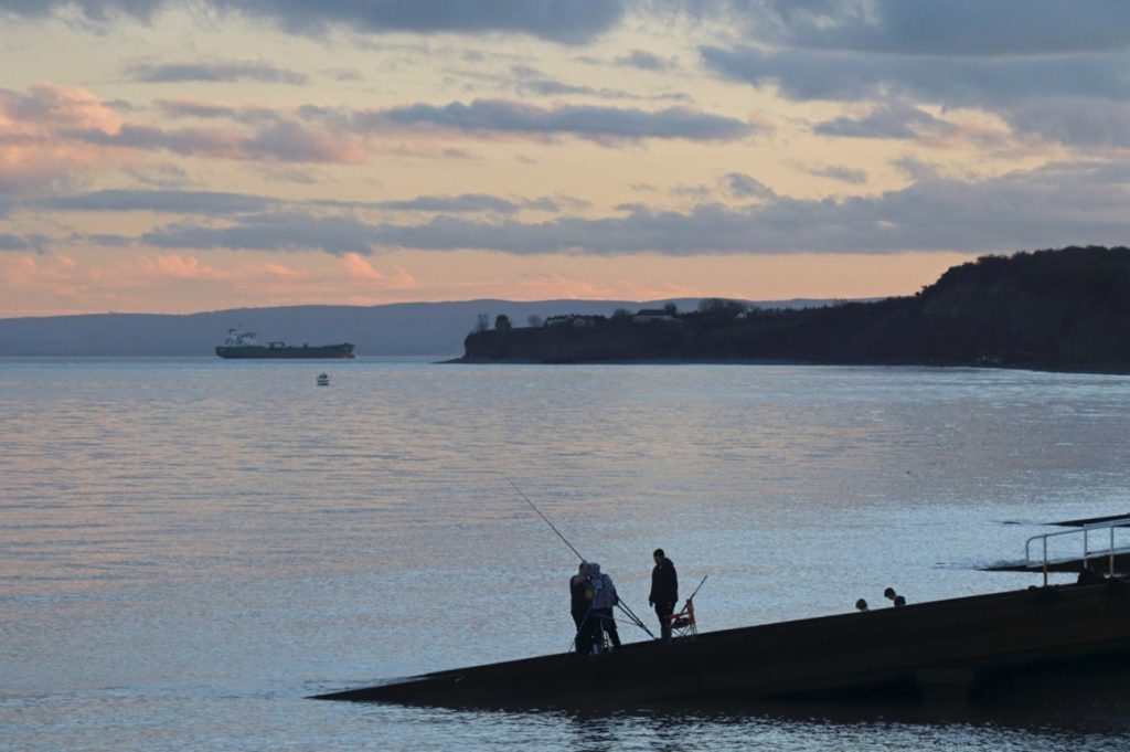
Carefully traversing the cobbles and rocky shore platform at Lavernock Point, we were treated to broad open views across the estuary to the islands and beyond as well as hidden treats in the innumerable rock pools and on the rock ledges themselves. As someone who occasionally likes to attempt landscape photography, the views across the Estuary always fascinate me. The ever-changing tides, sea state, weather and offshore boat/shipping activities make for endless photographic opportunities, even if they’re not always realised! Today, it was a particularly calm still day with little offshore activity although there was some distraction as the occasional but somewhat elusive oyster catcher flew by.
However, it was the ecology and geology of the rock pools and ledges and the artistic forms, textures and micro-seascapes created by them which were our focus on the foreshore today. As Heather is particularly interested in our rich intertidal areas which are only revealed at low tide, we spent awhile, and with varying degrees of success (at least on my part), trying to capture these hidden worlds photographically. In the slightly hazy mid-afternoon sunshine, the silvery mucus/slime trails of sea snails (molluscs) made intricate and complex abstract patterns on the rocks. Innumerable limpets and white beach lichen encrusted the harsh environment of the rock ledges. There was also added visual interest from occasional periwinkles, oyster shells and whelks. The colour of some bright red shiny shells, really ‘popped out’ from the underlying wet grey limestone slabs. As the tide was still receding, we were also able to witness the ever-changing worlds of turbid shallow rock pools in the mid-shore which were supporting the delicate feathery branches of floating ‘Coral Weed’ (the red seaweed, Corallina officinalis) and various small brown, branching wracks.
The similarities between some of the living molluscs on the shore and those from around 200 million years ago, now fossilised in the rocks and pebbles on the beach, was staggering. The analogies continued – we were looking at our own mini-‘Jurassic Park, comprising alternating beds of lighter coloured limestones and dark shales from the Lower Lias (Jurassic). These rocks were formed in a former marine environment, the configuration of which was controlled by an ancient Bristol Channel Basin. Perfectly-formed fossilised ripple marks in some of the rock slabs lay strewn across the beach were lying on top of- or at very close to -ripples made only hours before our visit in the muddy sands of the foreshore. The occasional impression of an ammonite, now of course long extinct was a reminder of the very different world of 200 million years ago.
The beach walk back to Penarth
Fortunately, we had a lovely calm day in which to explore the hidden gems of the beach and cliffs as we walked back from Lavernock Point as the tide began to turn. This is a much-celebrated stretch of geology culminates at its southern end in the amazing sequence of rocks at Penarth Head which has been designated as a Site of Special Scientific Interest. Unfortunately, on this visit we didn’t have time to explore Penarth Head itself or the site of the ‘dragon robber,’ meat-eating dinosaur (Dracoraptor hangigani), which was only discovered ten years ago close to Lavernock Point. However, we were able to still appreciate some of geology of the foreshore and cliffs as we walked back in time, traversing the even more ancient rocks of the Triassic. The distinct and brightly-coloured red and grey green mudstones of this stretch of coast are the remains of lake sediments laid down when this part of the ‘estuary’ was experiencing hot arid, desert-like conditions – certainly, not like those we experienced on our walk! Attractive pink and white gypsum forms distinctive, discontinuous bands in the cliffs along here, but given the active erosion that afternoon, we had to make do with just examining the large pink and white lumps of it which had recently fallen onto the beach. Interestingly, there was a relatively small and short-lived industry just east of Lavernock Point, based on this mineral. Alabaster, as it is more commonly known, was mined here from the 1872, and supplied many of the fine buildings of Cardiff with an ornamental stone particularly for indoor use. Indeed, the main staircase of Main Building in Cardiff University, where the Severn Estuary Partnership Office is housed, is adorned with an impressive display of pink alabaster!
Apart from the lumps of alabaster on the beach, we had further reminders of active cliff and beach processes, including armoured mud balls, curious rounded balls of mud clad with small jagged stones, which were scattered across the foreshore. Alongside the gentle noise of the sea lapping up on the beach, there was a constant ‘swish’ as slivers of shaley materials slid gently from the cliff profile. Then, a great ‘thud’ sounded as a dining table-sized slab of limestone crashed onto the upper beach! Unfortunately, the event was all over in a few seconds and, as I rushed to get my camera, all that remained was a small cloud of rock dust! A combination of undercutting from the base of the cliff, the weathering effect of tree roots intruding into the joints and cracks of the rocks of the upper cliff and the impact of our recent extremely wet weather certainly were making their mark that afternoon as we witnessed a number of further mini-landslides, all of which eluded my camera skills. As we walked further towards the seafront at Penarth, the need for human intervention for controlling these erosive processes became ever more apparent. Toe-protection structures eventually made way for full sea defences in front of the RNLI lifeboat station and the promenade beyond, confirming the need for the Hold the Line shoreline management policy for this northern section of our beach walk.
Overall Impressions
Back on the esplanade in Penarth as we sipped much-needed beverages at one of several establishments, we reflected on our experiences from the walk. Although I’ve walked this stretch of coast innumerable times before, introducing it to Heather had made me realise what a very special, unique sea/landscape this is. There are not only breath-taking views across the Channel, but also hidden worlds and amazing ‘natural art’ in the rocks and rockpools. Heather, whilst coming from the contrasting – and to us Severn folk, the much more ‘exotic’ tidal landscape of the Gulf of California – also seemed impressed with our ‘finds.’ Later commenting on some of her first impressions of our muddy shores, she highlighted the sense of mystery and the layers of history which have created our special shores.
FURTHER INFORMATION ON THIS WALK
If you want to do this walk along the Wales Coast Path, make sure you’re prepared for the weather and please take note of the tides before you go, ensuring you do the walk along the beach on a falling tide. Suitable footgear is also essential on the somewhat slippery and large cobbles, particularly on Lavernock Stony Beach.
If you want to find out more about this stretch of coast, check out the ‘Coast and Pier Walk’ – Sully to Penarth Pier Walk (5 miles / 8 km). See: https://assets-global.website-files.com/602452bf511ad639c3e8aab6/605ded4492408acf33e52ebc_5-Coast-and-Pier-Walk-online-leaflet-English.pdf
Further sources of information
Cosmeston Country Park and Medieval Village – https://www.valeofglamorgan.gov.uk/en/enjoying/Coast-and-Countryside/cosmeston-lakes-country-park/Cosmeston-Lakes-Country-Park.aspx
The dinosaur discovery at Lavernock Point – https://www.theguardian.com/science/2016/jan/20/welsh-dinosaur-bones-confirmed-as-new-jurassic-species
Marconi and Lavernock Point –
https://www.visitthevale.com/inspiration/whats-the-vales-link-with-marconi;
South Wales Geologists’ Association leaflet on the Penarth-Lavernock Point coast — http://swga.org.uk/wp-content/uploads/2020/01/Walk_Penarth.pdf
Western Gateway and the launch of the Severn Estuary Independent Commission – https://western-gateway.co.uk/western-gateway-launches-severn-estuary-commission-cardiff#:~:text=The%20estuary%20is%20home%20to,of%20the%20UK’s%20electricity%20needs

Heather exploring the rocky coast at Lavernock Point

View from cliff top back towards Penarth (from a previous even sunnier walk)
The plaque celebrating the first-ever radio transmission across the sea
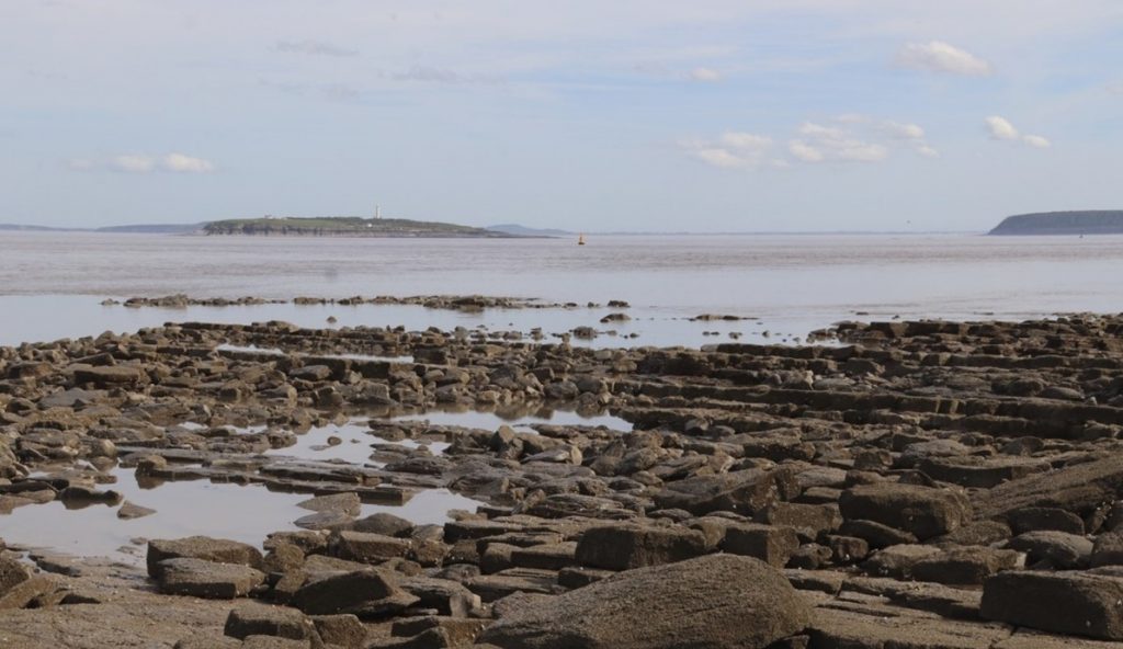
View from Lavernock Point across to the islands
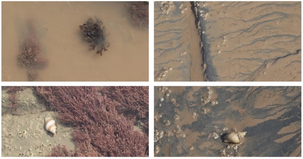
Foreshore worlds near Lavernock Point
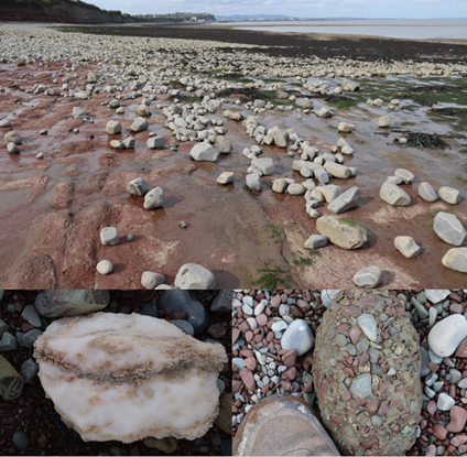
Some finds on the beach – red mudstones, pinky white gypsum (alabaster) and armoured mudballs
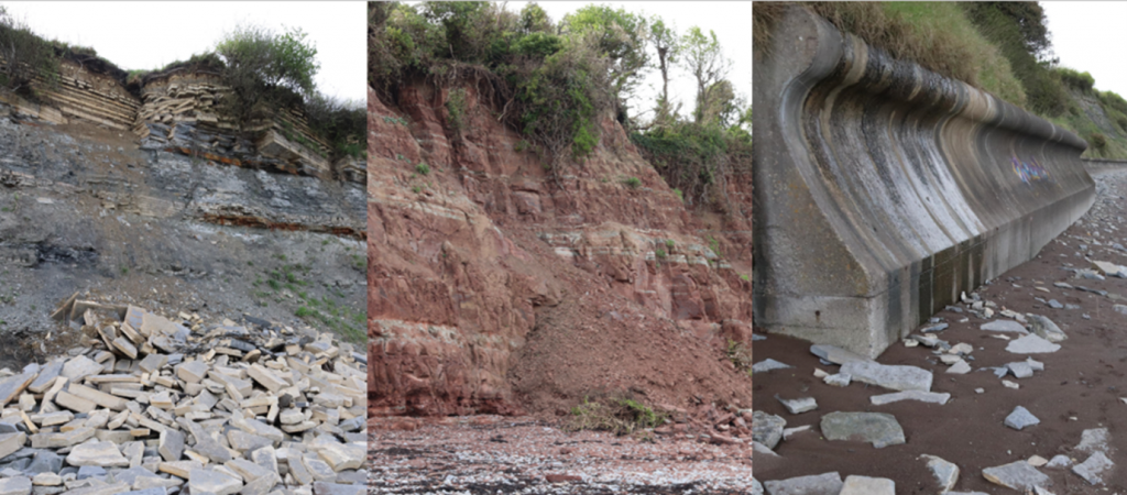
Active cliff processes along our beach walk
Evening at Penarth (Jan 2023)